The Aurora Islands
1762 – 1870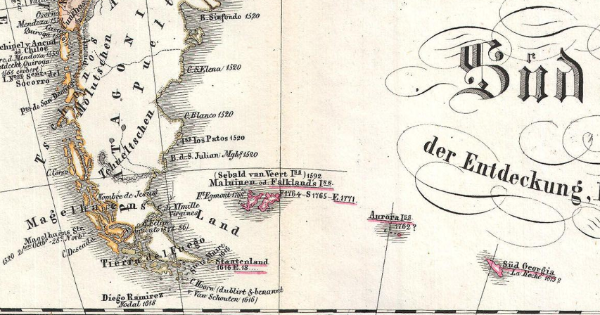
Where in the South Atlantic, between the Falklands and South Georgia
When first “sighted” in 1762 and last in 1856
May actually be Shag Rocks, an archipelago of six rocks belonging to South Georgia1
Appear in literature in The Narrative of Arthur Gordon Pym of Nantucket by Edgar Allan Poe (1838) and Terrae Incognitae by Barbara Hodgson (2001)
It is the year 1794, and the golden age of Spain is coming to an end. So is the golden age of exploration. They went hand in hand. Not too long ago, an adventurous captain could sail in a direction at random, and find either an archipelago where a new spice grew, or the temples of a mysterious people, or even an entire continent, full of marvelous beasts that no one had expected to be found in Creation. Not too long ago, a kingdom like Spain could gather an unprecedented fortune just by picking it up in the nooks of the world.
Not anymore, in the year 1794. In the year 1794, the Descubierta and the Atrevida are sailing about in the South Atlantic, at the close of a four year scientific expedition in the Pacific under the command of Alejandro Malaspina and José de Bustamante y Guerra. On the return trip to Cadiz, after having cleared Cape Horn and visited the Malvinas Islands, Malaspina sends Bustamante and the Atrevida to the east, with the goal of confirming the existence of a handful of remote rocks.
They were seen thirty-two years earlier by the Aurora of the merchant navy, which gave them her name. Mentionned a couple times since. Described summarily in 1790: three isles, aligned on a north-south axis.
In the year 1794, a scientific vessel, with all the eminents hydrographers and astronomers you could wish for among its crew, will settle their case once and for all.
But the Atrevida is coming back from four years of expedition in the Pacific, and one can imagine, on board, a certain weariness. In his journal, captain Bustamante complains about the unfavorable weather, which forces the frigate to a standstill while it endures the high waves. On January 20th, the first of the Aurora Island is seen at last. The weather conditions are not improving, and Bustamante decides to head north. Two other islands are located. Partially covered with snow, of vaguely pyramidal shape. It is impossible to land, but the crew is experienced enough to avoid mixing up an island with an iceberg, and this seems sufficient: on January 27th, Bustamante declares himself satisfied with the recorded observations, and the Atrevida heads back to the less treacherous shores of Patagonia, where the Descubierta is waiting.
It is the year 1794, and the golden age of Spain is about to end at the same time as the golden age of exploration. On his return to Europe, Alejandro Malaspina, commander of the greatest scientific expedition in Spanish history, is arrested and jailed on the charge of conspiracy against the State. The notes on natural and political history, the drawings and the paintings, the mineral and botanical samples: everything that was collected during the trip disappears from circulation. The materials will be rediscovered no earlier than in a hundred years.
Only one atlas is published—thirty-four maps of the seas and the Spanish possessions, from the western coast of North America to the Tonga, from the Philippines to the Tasman Sea. An excellent piece of work, except for a small detail: three little dots, on the map of the South Atlantic, that will pretend to exist for yet another half-century.